Project background
The City of Eugene would like to add protected bike lanes to Oakway Road and a small portion of Cal Young Road (between Oakway Road and Willakenzie Road). The City is also upgrading curb ramps at the Oakway Road, Coburg Road, and I‑105 intersection. This three-part project combines local, state, and federal funds and provides an opportunity to rethink how these streets and intersections look, feel and operate.
The City's long-range Transportation System Plan identifies Oakway Road and Cal Young Road as important bicycle connections – connecting the Cal Young Neighborhood to the Riverbank Path and downtown Eugene. Building protected bike lanes along Oakway Road and Cal Young Road increases the safety and comfort of people on bikes - making it easier to choose to ride a bike.
The Oakway Road, Coburg Road, and I-105 intersection is a critical juncture in the Cal Young Neighborhood but can be unpleasant to walk or ride a bike through. This project seeks to improve the walking and biking experience through this intersection.
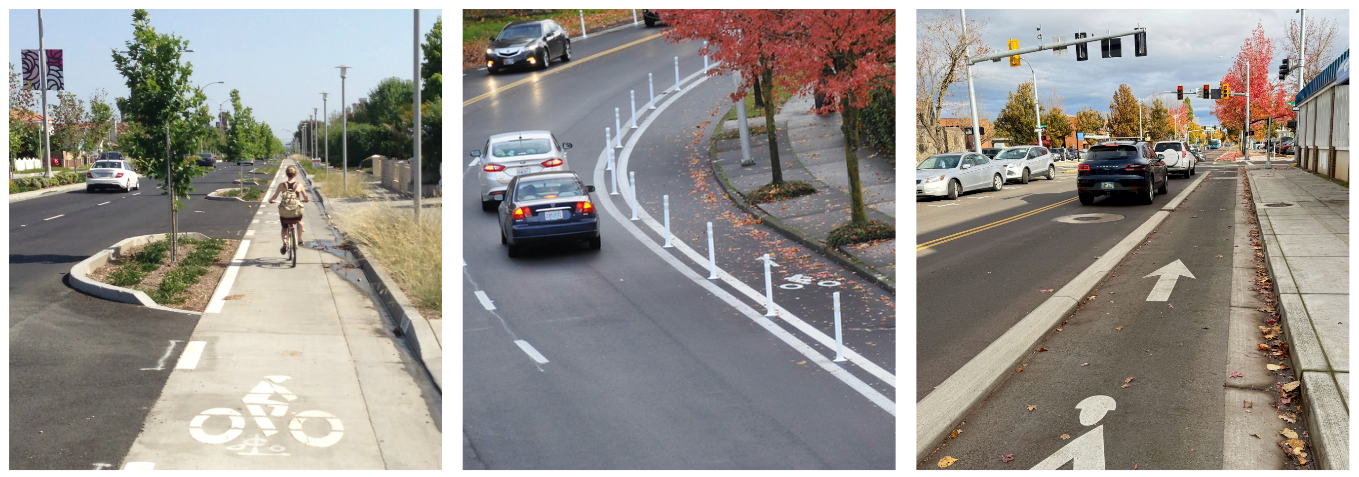
Protected bike lanes are bike lanes where physical elements separate people driving cars and people riding bikes. Examples of physical elements include planters, flexible bollards, and curbs, as shown in the images above.
What will the streets look like?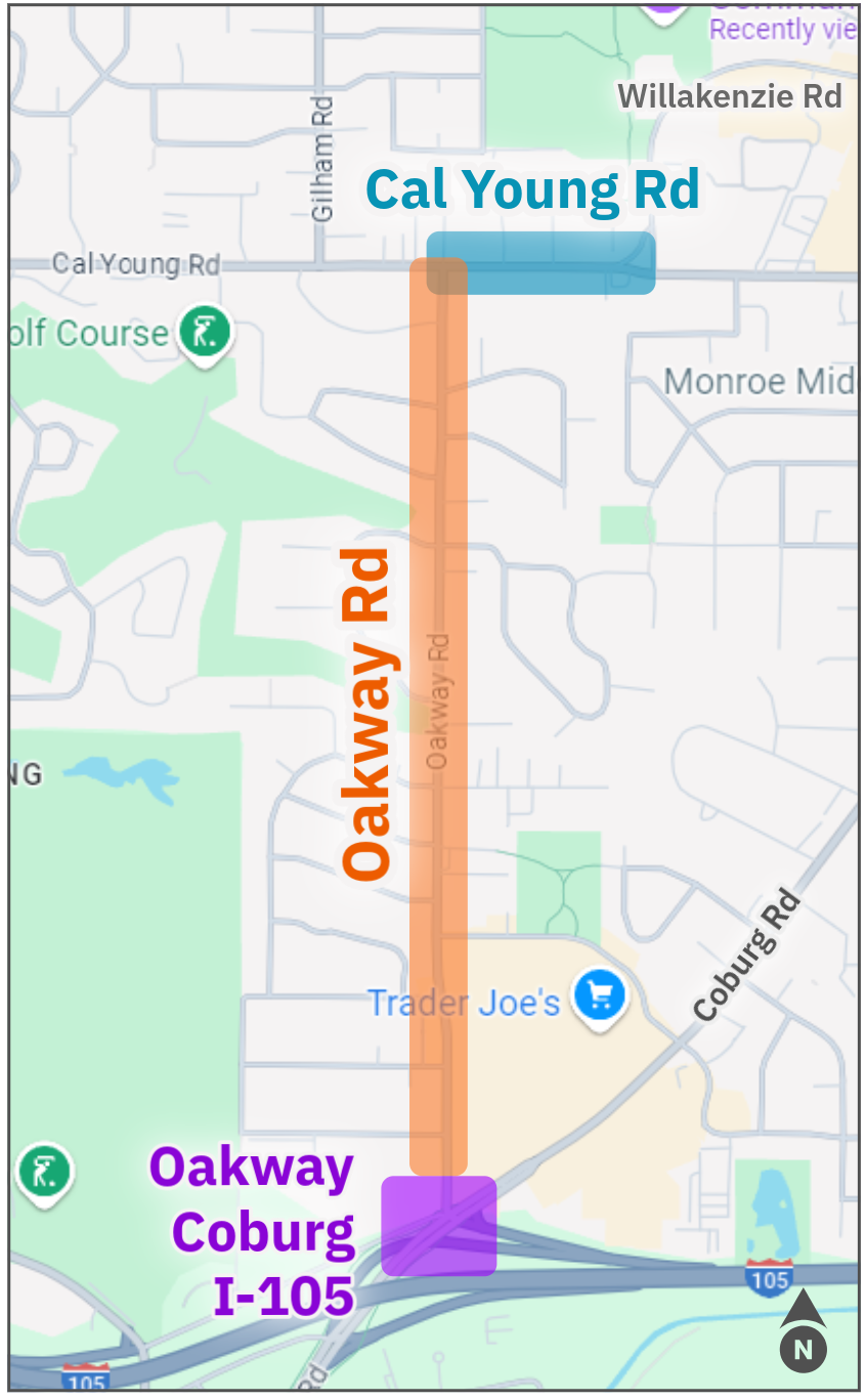 Map of project area
There are multiple design options for Oakway Road and Cal Young Road, each with their own set of tradeoffs and limitations. How space will be shared between people driving, parking, biking and walking has not yet been decided.
Key design elements include the availability of turn lanes and on-street parking, the configuration of protected bike lanes, where pedestrian crossing islands and bus stops are located, and where shared use paths may be preferred.
No decisions about final street designs have been made. The City considers many factors when making decisions about street design including operational needs, best practices, budget, project scope, City Goals, and community input.
How can I be involved?
Share your thoughts and provide input on future street design by taking project surveys, attending community meetings, and connecting with City staff. Engagement opportunities will be posted online and shared via email when available.
Next Steps
City staff are working in the background to identify different design options for Oakway Road that align with project intentions, budget, and best practices. This work, combined with what we hear from the community, will influence what design options are shared with neighbors for feedback and input.
Project background
The City of Eugene would like to add protected bike lanes to Oakway Road and a small portion of Cal Young Road (between Oakway Road and Willakenzie Road). The City is also upgrading curb ramps at the Oakway Road, Coburg Road, and I‑105 intersection. This three-part project combines local, state, and federal funds and provides an opportunity to rethink how these streets and intersections look, feel and operate.
The City's long-range Transportation System Plan identifies Oakway Road and Cal Young Road as important bicycle connections – connecting the Cal Young Neighborhood to the Riverbank Path and downtown Eugene. Building protected bike lanes along Oakway Road and Cal Young Road increases the safety and comfort of people on bikes - making it easier to choose to ride a bike.
The Oakway Road, Coburg Road, and I-105 intersection is a critical juncture in the Cal Young Neighborhood but can be unpleasant to walk or ride a bike through. This project seeks to improve the walking and biking experience through this intersection.
Protected bike lanes are bike lanes where physical elements separate people driving cars and people riding bikes. Examples of physical elements include planters, flexible bollards, and curbs, as shown in the images above.
What will the streets look like?Map of project area
There are multiple design options for Oakway Road and Cal Young Road, each with their own set of tradeoffs and limitations. How space will be shared between people driving, parking, biking and walking has not yet been decided.
Key design elements include the availability of turn lanes and on-street parking, the configuration of protected bike lanes, where pedestrian crossing islands and bus stops are located, and where shared use paths may be preferred.
No decisions about final street designs have been made. The City considers many factors when making decisions about street design including operational needs, best practices, budget, project scope, City Goals, and community input.
How can I be involved?
Share your thoughts and provide input on future street design by taking project surveys, attending community meetings, and connecting with City staff. Engagement opportunities will be posted online and shared via email when available.
Next Steps
City staff are working in the background to identify different design options for Oakway Road that align with project intentions, budget, and best practices. This work, combined with what we hear from the community, will influence what design options are shared with neighbors for feedback and input.

